RED RIVER GORGE
Short Hikes
Short Hikes
|
|
RED RIVER GORGE
Short Hikes |
|
Use our Map to find hikes of the length you are looking for. For the first-time visitor to the area, we recommend the following short hikes to get an overview of the Gorge and Natural Bridge: Straight ahead you will see Pinch'em Tight ridge. At the right-hand end of the ridge you see a Cliff known as Hole in the Wall or Revenuer's Rock (you can see how it got the name Hole in the Wall, it got the name Revenuer's Rock from the days when revenuers would watch from the top to spot the tell-tale smoke trails from Moonshiners). Between Hole in the Wall and the rest of Pinch'em Tight Ridge there is a small breakdown where people can cross from one side of the ridge, across the top of the ridge, to the other side. This is the 'Pinch' that Pinch'em Tight Ridge is named after. A loop around Hole in the Wall through the Pinch, starting from the Sheltowee Trace parking area, makes a neat but strenuous off-trail day hike for advanced hikers. To your left you will see Half Moon Rock, which contains the small Half Moon Arch to the left. This is a favorite spot for rappellers, so expect to see ropes in place as people hurtle themselves down the cliff face and climb back up Ellen's Descent, on the very end of the Rock. To the right, you can follow along the narrow valley of Red River Gorge and trace the path that the Red River has carved through soil, limestone, and sandstone. Way off in the distance you will see a singular orange rock cliff rising tall from the valley below. This is Raven's Rock, if you came through Nada Tunnel and crossed the Steel Bridge along Route 77, you would have seen Raven's Rock on your left. 2. Hike to the Natural Bridge. Approximate Length: 1.5 miles. Park in the lot for the "Trails To Natural Bridge", or if you are staying in Hemlock Lodge, walk behind the building along a narrow paved service road to the start of the trails. Take the Original Trail to the top of Natural Bridge, this trail is VERY STEEP but worth the effort. Squeeze through Fat Man's Misery to get to the top. After spending some time on top of Natural Bridge, look for the shelter house near where you first reached the top of the Bridge. Balanced Rock Trail begins here, take Balanced Rock trail back down to your vehicle. Interesting Side Trip: As you are proceeding down Balanced Rock Trail to your car, you will see what looks like a huge Rock House to your left that seems to extend back forever into blackness. This is actually a cave that comes out through a small opening onto the Original Trail. If you have a reliable flashlight, go through the cave, turning right when the cave forks to find the small opening at the other end. If you can't find the opening at the other end, turn off your flashlight and let your eyes adjust, you should see a small amount of daylight pointing you to the exit. 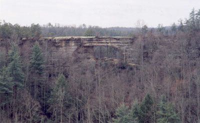
3. Sky Bridge. Drive to the Sky Bridge Parking Area along Route 715 near the eastern end of the Gorge. Many short walks to overlooks can be found here as well as a trail that crosses Sky Bridge and descends down to the base of it. 4. Rock Bridge Paved Trail. Approximate Length: 1.3 miles. This is the only natural arch in the area that crosses a river and has water running through it. Park at the Rock Bridge parking area at the end of the gravel road. The start of the trail is toward the right-hand (east) side of the lot across from the restrooms. Hike to Creation Falls, then continue to Rock Bridge and loop around back to the parking lot. |
| Short Hikes | Day Hikes | Backpacking | Climbing | Fishing | Canoeing |
|